
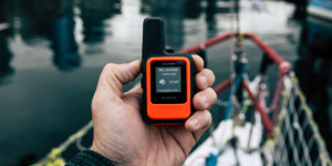
Garmin International announced the inReach Mini, a smaller and more compact satellite communicator with available two-way messaging and a 24/7 SOS function when combined with an inReach subscription to access the Iridium satellite network. Measuring just under 4 inches tall by 2 inches wide, and weighing 3.5 ounces, the inReach Mini can easily be carried in a backpack, boat, plane, or glovebox. No more worrying about spotty coverage or being within range of a cell tower – the inReach Mini works anywhere when using the Iridium satellite network.
“We are thrilled to introduce the inReach Mini into our growing line of satellite communicators,” said Dan Bartel, Garmin vice president of global consumer sales. “You’ll never have to sacrifice space or weight in your pack; it’s small enough to stow nearly anywhere so it can be out of sight but still give you – and your loved ones at home – peace of mind that it’s there when you need it. The inReach Mini is an invaluable companion no matter where or how far off-the-grid life takes you, from trail running to traveling internationally to search and rescue efforts.”
For the ultra-light experience, the inReach Mini encompasses it all, from messaging to tracking to declaring an SOS. It can be used on its own or paired with a compatible device. The Earthmate® app easily pairs with the inReach Mini via Bluetooth to a compatible smartphone1 for access to unlimited maps, aerial imagery, and U.S. NOAA charts. The Earthmate app also allows all of the inReach features to be accessed through the paired mobile device, so a user can reach anyone in their contact list. The app will seamlessly allow the user to access their compatible device’s contact list for quick access without manual entry.
Connected With Others Garmin Devices
The inReach Mini also works with Garmin’s increasingly popular fēnix smartwatch line to send and receive messages from their watch with the device securely fastened to their pack, kit, or vehicle. The user can remotely program the device to send and receive messages with compatible Garmin handhelds, wearables or other mobile devices. For example, a trail runner can be off the beaten path and be using their watch to not only track their stats but remotely control their inReach Mini to send and receive messages. See all compatible devices here.
Pilots will also have the same ability to send and receive messages conveniently through their Garmin Pilot™ app right from the cockpit. Garmin Pilot leverages the inReach Mini’s GPS positioning to drive a georeferenced aircraft position symbol on a tablet’s moving map display. The device has the ability to provide tracking for those wanting to follow the flight, using the web-based MapShare™ page created for each inReach account.
Like all inReach devices, a user can hit the SOS button in case of emergency that sends a distress signal to GEOS®, a 24/7 International Emergency Response Coordination Center. GEOS will track the device which triggered the SOS, notify the proper contacts, and send the necessary emergency responders to the exact location. GEOS will deliver a confirmation that help is on the way and also continually update the user on the status of the response team. GEOS will also reach out to the user’s emergency contact and alert them of the situation.
Every inReach device also gives users access to a cloud-based website to not only plan future trips with specific waypoints and routes, but to create preset messages and quick texts. In the website, users can sync and manage their device settings, update firmware, link social media accounts and store unlimited location tracking data. To receive weather forecasts, the optional service provides detailed weather updates directly to the inReach Mini. Users who choose either the basic or premium package offered for land or marine forecasts will know the conditions for a current location, a waypoint, or future destination.
An Access to The Iridium Network
To access the Iridium network and communicate with an inReach Mini device, an active satellite subscription is required. Depending on the frequency of use, a variety of airtime plans that range from flexible month-to-month options to an annual contract package are available for individuals or professionals.
Small but mighty, the inReach Mini is impact resistant (MIL-STD-810F) and water-rated to IPX72, so it’s built tough to withstand extreme conditions. The inReach Mini includes an internal, rechargeable lithium battery for up to 50 hours of use at the default 10-minute tracking mode and up to 20 days at the 30-minute interval extended tracking mode3. Available in Q2 2018, the inReach Mini will have a suggested retail price of $349.99. To learn more, visit www.garmin.com/inreach.
The inReach Mini is the latest solution from Garmin’s expanding outdoor segment, which focuses on developing technologies and innovations to enhance users’ outdoor experiences. Whether hiking, hunting, trail running, mountain biking, golfing, diving or using satellite communication, Garmin outdoor devices are becoming essential tools for outdoor enthusiasts of all levels. For more information about Garmin’s other outdoor products and services, visit www.garmin.com/outdoors.
For decades, Garmin has pioneered new GPS navigation and wireless devices and applications that are designed for people who live an active lifestyle. Garmin serves five primary business units, including automotive, aviation, fitness, marine, and outdoor recreation. For more information, visit Garmin’s virtual pressroom at garmin.com/newsroom, contact the Media Relations department at 913-397-8200, or follow us at facebook.com/garmin, twitter.com/garmin, or youtube.com/garmin.
Read More About Garmin
Garmin unveils Ultra High-Definition Scanning Sonar
10 Tricks For Recovering and Transferring Your GPS Data
Leave a Reply